Lansing has a really great trail system for recreational biking. However, many people rely on bikes for transportation to work, school and for everyday errands. If you do not live right on the river trail, at some point you are going to need to use the city's other transportation infrastructure. Lansing does not have any protected lanes at this time, which means cyclists and drivers often share the roads. When there are no barriers between cars and bikes, collisions are more likely.
The Michigan Office of Highway Safety Planning maintains a public site of collisions involving cars. Here is a visualization of where those collisions occur when they involve bikes. This paints a picture of where cyclists need to go but do not have access to safe routes. All of the orange points involve injuries; one at the corner of Miller and Cedar resulted in a cyclist's death.
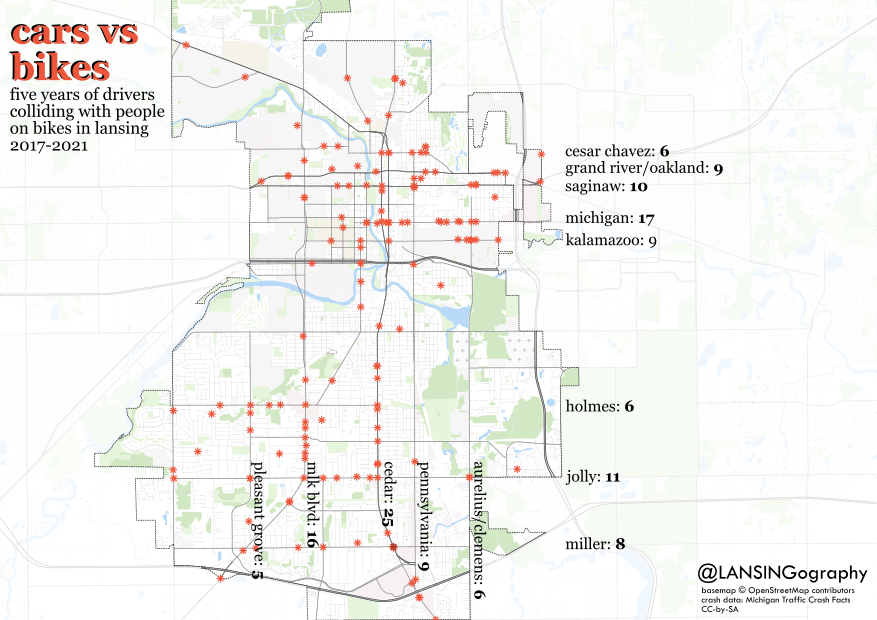
The streets are not all the same length, so it's not an equal comparison, however it's easy to notice that Michigan Ave has a high number of impacts for a shorter road. There is a planning commission looking at redesigning Michigan Ave in the future called Michigan's Ave. If you have ideas on how you'd like Michigan to look in the future, they are asking people to fill out their survey.
What patterns do you see? How can we ensure our streets are safe for all Lanstronauts: those walking, wheeling, cycling, and driving?
Edit: follow up by request, here is a similar map of cars vs walkers/wheelchairs:

No comments:
Post a Comment